
How a Mineral County Property Search Works
The WV Property Assessment Search is the main online entry for Mineral County parcels. Set the county to Mineral first. Street Name suits a known location, and Owner Name fits a likely holder. Full Parcel ID fits an exact key. District, Map Number, Parcel, and Sub-Parcel narrow a broad search. Modes help too. The search offers Basic, Appraisal/Sales, Advanced, and Prior Ownership views. One street query never has to carry every filter.
An assessment row can lead to a GIS map. The deed is still the evidence. The route runs address to parcel, parcel to owner and value, then owner or legal description to the Clerk's land index and the property records it holds. Bill questions belong to the Sheriff-Tax system. The WV Property Viewer runs separate address, owner, parcel, geometry, and coordinate searches, and it shines once an assessment row supplies a parcel clue.
- Choose Mineral County and enter the street name, owner text, or parcel key that you know.
- Open the matching row and note Current Owner, Property Address, district, map, parcel, and root parcel ID.
- Use deed book and page or the legal description to search the Clerk’s recorded land index.
- Open the linked map or search the WV Property Viewer to compare physical location and parcel geometry.
- Contact the relevant office for a paper record, missing image, correction, or certified copy.
Mineral County Property Search Field Guide
The assessment form holds more than three keys. Its appraisal and sales panel narrows by value, acres, sale period, and price. Advanced fields go deeper. They add deed references, legal text, and structure traits. Filter matching rules stay unclear, so begin broad and refine only when a result set grows unwieldy.
| Field label | Type | Required | Format or use |
|---|---|---|---|
| County | Dropdown | No | Select Mineral |
| District | Dropdown | No | Options populate after county selection |
| Full Parcel ID | Text | No | Full state parcel identifier |
| Owner Name | Text | No | Indexed owner text; match behavior not stated |
| Map Number | Text | No | County map identifier |
| Property Class | Dropdown | No | Class options load by county |
| Street Name | Text | No | Supports a street-level parcel list |
| Parcel | Text | No | Parcel segment |
| Tax Class | Dropdown | No | Tax-class filter |
| Sub-Parcel | Text | No | Suffix or sub-parcel segment |
| Land Use | Dropdown | No | Land-use code |
| Min/Max Land Appr | Number pair | No | Land appraisal range |
| Min/Max Building Appr | Number pair | No | Building appraisal range |
| Min/Max Total Appr | Number pair | No | Total appraisal range |
| Min/Max Calc Acres | Number pair | No | Calculated acreage range |
| Min/Max Deeded Acres | Number pair | No | Deeded acreage range |
| Sale From/Through | Date pair | No | Recorded or sale date range |
| Min/Max Price | Number pair | No | Sale-price range |
| Flood Hazard | Dropdown | No | Flood-hazard filter |
| Mailing Address | Text | No | Owner mail location, not situs |
| Deed Book | Text | No | Recorded book cross-reference |
| Page | Text | No | Recorded page cross-reference |
| Legal Description | Text | No | Search deed description text |
| Building Year Min/Max | Number pair | No | Structure age range |
| Primary Structures Min/Max | Number pair | No | Structure-count range |
| Building Area Min/Max | Number pair | No | Building-area range |
| Secondary Structures Min/Max | Number pair | No | Additional structure count |
| Lines per page | Number | No | Result display size |
| Display legal description | Checkbox | No | Adds the description to output |
| Display GIS parcel ID | Checkbox | No | Adds the map-system identifier |
Open the WV Assessment Search form to see the tabs and exact labels. The public form needs no login, and the result list is free. A complete document image may live elsewhere.
See the MapWV assessment search for supporting context. 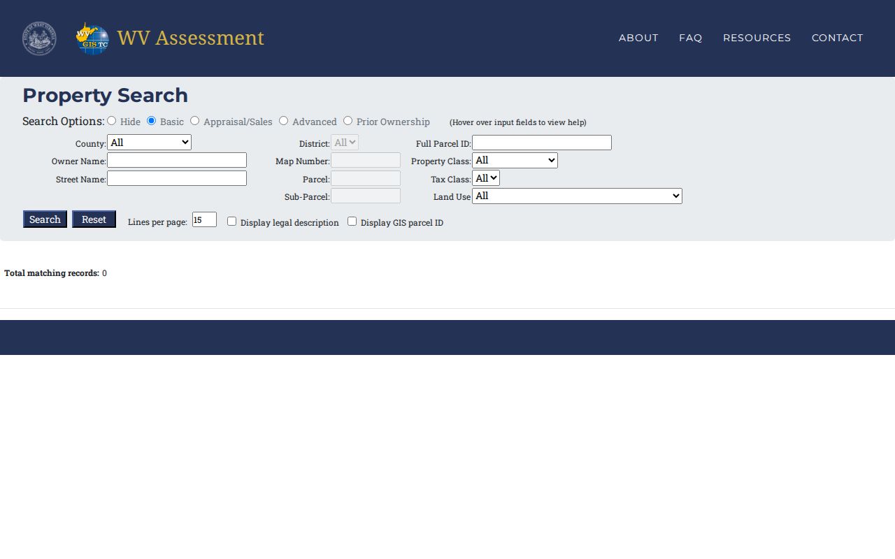 shows the form before a query is run. It helps distinguish the simple location search from the Appraisal/Sales filters.
Mineral County Owner Names Need a Second Clue
Owner Name can pull every matching parcel tied to the indexed text, which helps when the goal is land held by one person or entity. Still, a name alone is a weak match key. Mineral County is small, and common surnames repeat. Add a town, street, middle initial, parcel part, or mailing address wherever the form allows it. A trust, estate, or limited liability company may be indexed under its legal name rather than the person who manages it.
Never assume one owner row means one owner. The assessment summary may show just a single name and address. The detailed card tells more. It reveals multiple owners and a separate mailing address. Compare the result's Property Address against the physical place in question. A mailing address elsewhere is worth noting. A shared surname, an old street name, or a nearby spot sharing the same postal city can make two parcels look alike.
Entity names get one more check. West Virginia's Secretary of State business search shows status, registered office, and agent filings. Those filings can link a deed grantee to a named entity, though they do not necessarily name the beneficial owner. The deed records still hold the last word.
What a Mineral County Property Record Shows
A Mineral County property record ties one owner of record to one parcel and its valuation. The core fields tell the story. A typical assessment row carries the root parcel number, the current owner, the property address, county and district, the map, a GIS map link, a flood indicator, deeded acres, property class, land-use code, and tax class. Three appraisal values usually sit alongside those labels. A second card can add building details, cost figures, flood specifics, the community, and a full parcel assessment report.
| Current Owner | Name shown in the assessment roll; detailed card may show co-owners |
|---|---|
| Property Address | Physical or situs address; mailing address can differ |
| Root Parcel ID | Links county, district, map, parcel, and suffix parts |
| Property Class and Land Use | Classification fields for the assessed parcel |
| Flood and Acres | Flood indicator and deeded-acre figure |
| Building, Land, Total Appraisal | Separate appraisal values shown for the assessment record |
| Deed Book and Page | Search fields for a recorded reference; not a full deed image |
The property search form reaches further back too. It accepts sale date ranges and minimum and maximum price. Deed book, page, and legal description fields are also available. One caution: a blank last-sale block does not prove no deed or transfer exists. The display can be incomplete. Treat any search result as a lead to a record rather than a title opinion, an appraisal, or a survey.
Mineral County Parcel IDs Are the Exact Link
Once a result surfaces, copy the full root parcel ID. Don't retype a short map-and-parcel fragment. West Virginia's root pattern stacks county code, district code, map, and parcel prefix. It also adds a suffix and a special ID. The IAS assessment search may show a version with the county code stripped off. Don't confuse a state example with a Mineral County value. The county publishes no Mineral-specific prefix list on those source pages.
The parcel number works everywhere. It links the assessment roll, the GIS map, and the tax-map product. It also ties into a Clerk records request. For an old tract that was split or combined, though, the modern ID may not match. The historic deed description may differ. Carry both when you ask the Clerk to trace a transfer. Bring the current parcel number and the legal description.
A mailing city is not a boundary. A Keyser, Piedmont, or Ridgeley address can be postal geography reaching beyond the incorporated town. Confirm any city-limit question with the town clerk and its map. Never use the city name in an address field.
Mineral County Address Searches Miss Rural Routes
The GIS viewer speaks E-911. Its address format wants a street address, city, and state abbreviation, drawn from the SAMS source. It ignores rural-route or PO-box text entirely. A historic letter, tax receipt, or deed that lists only a route number needs a modern street or parcel clue first. A mail address can lead you to the owner of record. It will not show where the land lies.
Street names and numbers change over time, and Mineral County publishes no complete street-renumbering index. For an old Keyser, Piedmont, or Ridgeley address, try the town's former name if you know it. Check newspaper notices and ask the city clerk for address or annexation records. Then compare what you find against the Assessor's parcel and the deed description.
When no exact address match appears, broaden the search. Switch to Street Name and scan a block of candidate parcels. Use the owner's mailing address, acreage, map number, and deed book and page as cross-checks instead of forcing a single result.
Mineral County Result Links Open the GIS Record
Each Mineral County assessment result carries a GIS Map link. It moves the lookup from the tax roll onto the state parcel viewer. The map accepts a full parcel ID. It also takes county, district, map, parcel, and suffix pieces. E-911 addresses, owner names, geometry, and coordinates work too. A parcel card there can list the physical address, flood zone, community, building and cost values, and owner of record. It also offers a downloadable KMZ file.
The selected Mineral parcel view lets you set the assessment row beside the map detail. A URL query does not reliably open one parcel, though. Pick Mineral County in the viewer's county selector. Then copy the parcel number straight from the assessment result.
See the selected Mineral parcel view for supporting context.  shows the selected-parcel interface captured for the county. For map-layer interpretation and legal boundary cautions, the separate parcel map workflow is more useful than a search result alone.
Mineral County Appraisal and Sale Filters Differ
The Appraisal/Sales tab searches by minimum and maximum land, building, and total appraisal. Deeded and calculated acres, sale date range, and price range are options as well. Narrowing visible assessment rows is the purpose. It is not a deed image search. The appraisal figures in a result are the Assessor's values. Any sale price comes from transfer data and belongs in the recorded instrument for confirmation.
Set the ranges only after pinning down a district or road. A tight price or acreage band can hide a parcel when a field was left blank. The data can lag too. The viewer caps results at 1,000 rows. A broad countywide sweep may need sharper filters or a CSV export.
Mineral County assessment books run on an annual cycle. A freshly recorded deed can outrun the portal. Official guidance gives the state a February 1 deadline for July-to-June parcel changes. The cycle closes after that.
Mineral County Search Results Have a 1,000-Row Cap
The WV Property Viewer caps any result set at 1,000 rows. It also exports results to CSV. The assessment search shows the same 1,000-record limit, a page count, and a CSV Results control. An export suits a street or district review. Keep the filters and date with the file, though. That way the list can be rebuilt later.
Maps can hide stacked parcel cards or several owners. The viewer warns that a result row may show one owner and one physical address. Even the detailed parcel may hold more. Open the details panel for the fuller owner, building, flood, and assessment data. Draw conclusions about a Mineral County parcel only after that.
When the online list runs dry, the County Clerk's counter and phone line remain the fallback. Use them for older deeds and images. Ask there for the exact index range and copy cost. Mineral County publishes no web-index cutoff year or fee schedule online.
Search by Address, Owner, or Parcel
Address, owner, and parcel searches answer different questions. An address is the easiest entry point. An owner name can surface related parcels across Mineral County. A parcel ID is the most exact key once you have it. Pick a starting point. Then confirm with the same district, map, and parcel number, or the legal description, in the next record source you open.
| Search Key | Best For | Where It Works | Watch Out |
|---|---|---|---|
| Street address | One physical place or a street-level list | Assessment Search; GIS Viewer | E-911 form excludes rural routes and PO boxes |
| Owner name | Parcels indexed to a person or entity | Assessment Search; Clerk index by parties | Common names, trusts, LLCs, and co-owners need checks |
| Parcel ID | Exact current parcel link between offices | Assessment, GIS, tax-map request | Parts and formats vary between systems |
Not a title search. A Mineral County property search points to records of record and can miss an older, restricted, or unindexed instrument. It does not confirm clear title or legal boundaries.